Page 1 of 2
MapView - Layer with street and town names
Posted: Sunday 14th March 2021 11:36am
by 01McAc
I am experimenting with the component MapView. Purpose is to get a fast GPS exif browser for jpg and raw files. I am struggling with different layers in Google Maps. How can I enable or disable different layers of in Google Maps like street/town names, topographic view, etc.
What I see right now for the coordinates 52.52033763987445, 13.376083912073048 is the following
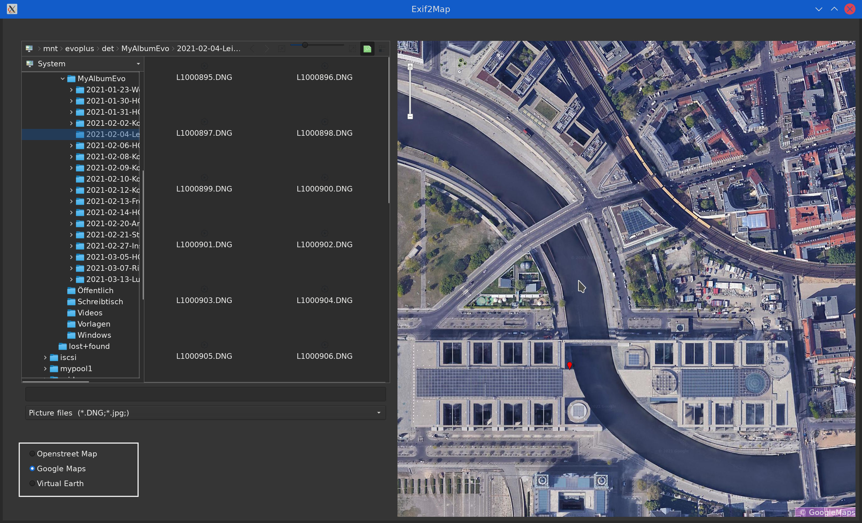
- Maps.jpg (817.43 KiB) Viewed 6866 times
InLat=52.52033763987445 and
InLon=13.376083912073048
Public Sub ShowMap(InLat As Variant, InLon As Variant)
  Dim iZoom As Integer
  Dim fLatitude, fLongitude As Float
  Dim sCacheName, sTileName, sTilePattern As String
  Dim cArguments As New Collection
  Dim sPoint As String
  Inc iCounter

  iZoom = 13
  sTileName = "OpenStreetMap"
  sTilePattern = "http://{s}.tile.openstreetmap.org/{z}/{x}/{y}.png"

  cArguments = Null
  sCacheName = Null
  fLatitude = CFloat(InLat)  ' °Lat
  fLongitude = CFloat(InLon) ' °Lon
  sPoint = CStr(fLatitude) & ", " & CStr(fLongitude)
  Debug RB_Openstreetmap.Value
  Debug RB_GoogleMaps.Value

  If RB_Openstreetmap.Value = True Then
    sTileName = "OpenStreetMap"
    MapView1.Map.AddTile(sTileName, sTilePattern, cArguments, sCacheName)
    MapView1.Map[sTileName].Copyright = " © OpenStreetMap"
  Endif

  If RB_GoogleMaps.Value = True Then
    sTileName = "GoogleMaps"
    MapView1.Map.AddTile("GoogleMaps", "https://khms{s}.google.it/kh/v={version}&src=app&x={x}&y={y}&z={z}&s=Galile", ["version": "869"]).SubDomains = ["0", "1", "2"]
    MapView1.Map[sTileName].Copyright = " © GoogleMaps"
  Endif

  If RB_virtualearth.Value = True Then
    sTileName = "VirtualEarth"
    MapView1.Map.AddTile(sTileName, "http://ecn.dynamic.t{s}.tiles.virtualearth.net/comp/ch/{q}?mkt=fr-fr&it=G,VE,BX,L,LA&shading=hill&n=z&cb=1").SubDomains = ["0", "1", "2"]
    MapView1.Map[sTileName].Copyright = " © VirtualEarth"
  Endif

  MapView1.Map.DefaultCache = "/tmp"
  MapView1.Map[sTileName].Visible = True ' optional;
  MapView1.Map.AddShape("P" & iCounter)
  'MapView1.Map!P1.AddPoint(sPoint, MapPoint(fLatitude, fLongitude))
  MapView1.Map["P" & iCounter].AddPoint(sPoint, MapPoint(fLatitude, fLongitude))
  MapView1.Map.Center = MapPoint(fLatitude, fLongitude)

  MapView1.Map.Zoom = iZoom
  MapView1.AllowEffect = True
End ' ShowMap()
Any ideas?
Re: MapView - Layer with street and town names
Posted: Sunday 14th March 2021 3:22pm
by cogier
You might like to look at 'PhotoEXIF' that I wrote. It is on the Gambas Farm. This manipulates the URL to get what I wanted. You want more! I notice that the URLs change depending on what feature you request. I have not worked out what all the codes in the URL do, but you can see the changes. Try these of the island of Guernsey where I live.
Normal view
Satellite view
Terrain view
Traffic view
The URLs are: -
https://www.google.com/maps/@49.4616719,-2.5680989,13.37z
https://www.google.com/maps/@49.4616719,-2.5680989,8717m/data=!3m1!1e3
https://www.google.com/maps/@49.4616719,-2.5680989,13.37z/data=!5m1!1e4
https://www.google.com/maps/@49.4616719,-2.5680989,13.37z/data=!5m2!1e1!1e4
Re: MapView - Layer with street and town names
Posted: Sunday 14th March 2021 4:51pm
by stevedee
Yes you need to change the "
pattern" argument to display the required layer.
So for a
Road Map:-
Code: Select all
MapView1.Map.AddTile("GoogleMap", "http://mt0.google.com/vt/lyrs=m&hl=en&x={x}&y={y}&z={z}")
:-
Code: Select all
MapView1.Map.AddTile("GoogleMap", "http://mt0.google.com/vt/lyrs=s&hl=en&x={x}&y={y}&z={z}")
:-
Code: Select all
MapView1.Map.AddTile("GoogleMap", "http://mt0.google.com/vt/lyrs=t&hl=en&x={x}&y={y}&z={z}")
Its the "
p&hl" bit that changes.
Re: MapView - Layer with street and town names
Posted: Sunday 14th March 2021 7:01pm
by 01McAc
@cogier: I'll have close look into the PhotoExif program tomorrow. After a first quick run through it looks 'wow' but throws an error when clicked and changed to another directory. It is very interesting how the exif information gets extracted. My app is much simpler and just focused on GPS and the mapview.
How is life in Guernsey? Must be a lovely spot especially in time of Covid-19.
@stevedee: Road map and satellite both work but terrain shows just a black rough surface in mapview.
Its the "p&hl" bit that changes.
What do you mean exactly?
Thanks you both of you. I'll try (and error) in the next couple of days.
Another question is about raw files. Filemanager Dolphin and others provide a preview of a raw file *.DNG. FileView ind Gambas doesn't. Can I train FileView somehow to show a preview of DNG-files?
Re: MapView - Layer with street and town names
Posted: Sunday 14th March 2021 9:15pm
by stevedee
01McAc wrote: ↑Sunday 14th March 2021 7:01pm
...@stevedee: Road map and satellite both work but terrain shows just a black rough surface in mapview.
That layer is described as Terrain Only so I guess that's what you are getting. Try this one:-
Code: Select all
MapView1.Map.AddTile("GoogleMap", "http://mt0.google.com/vt/lyrs=p&hl=en&x={x}&y={y}&z={z}").Copyright = "© GoogleMaps"
Its the "p&hl" bit that changes.
What do you mean exactly?
The only bit that changes in this sequence of "patterns" for different Layers is: "m&hl"..."p&hl" ... "s&hl" ... "t&hl" ... "y&hl" ... "r&hl
...Can I train FileView somehow to show a preview of DNG-files?
You will need a utility to either convert RAW into another format or to extract the small jpeg image that is embedded in RAW files.
Note that DNG is just one RAW format. Most camera manufacturers have their own format.
Re: MapView - Layer with street and town names
Posted: Monday 15th March 2021 11:19am
by stevedee
01McAc wrote: ↑Sunday 14th March 2021 7:01pm
...@stevedee: Road map and satellite both work but terrain shows just a black rough surface in mapview...
Yes the Terrain Only Pattern doesn't do anything.
But I found that "h" produces a strange map layer...
Re: MapView - Layer with street and town names
Posted: Monday 15th March 2021 12:06pm
by BruceSteers
stevedee wrote: ↑Sunday 14th March 2021 9:15pm
01McAc wrote: ↑Sunday 14th March 2021 7:01pm
...@stevedee: Road map and satellite both work but terrain shows just a black rough surface in mapview.
That layer is described as Terrain Only so I guess that's what you are getting. Try this one:-
Code: Select all
MapView1.Map.AddTile("GoogleMap", "http://mt0.google.com/vt/lyrs=p&hl=en&x={x}&y={y}&z={z}").Copyright = "© GoogleMaps"
Its the "p&hl" bit that changes.
What do you mean exactly?
The only bit that changes in this sequence of "patterns" for different Layers is: "m&hl"..."p&hl" ... "s&hl" ... "t&hl" ... "y&hl" ... "r&hl
...Can I train FileView somehow to show a preview of DNG-files?
You will need a utility to either convert RAW into another format or to extract the small jpeg image that is embedded in RAW files.
Note that DNG is just one RAW format. Most camera manufacturers have their own format.
Does Image class not convert raw to jpg ?
My icon maker app loads all manner of image types and saves as many different types even .ico but all it uses is Image.Load() Image.Save()
I'm not entirely sure what you are doing but i get the feeling Image class is your friend here being able to load many formats and even extract parts of an image.
All the best
Re: MapView - Layer with street and town names
Posted: Monday 15th March 2021 12:37pm
by 01McAc
Does Image class not convert raw to jpg ?
Unfortunately not. When I load the DNG file
hImageIW = Image.Load(FileChooser1.SelectedPath)
there are a few messages from the interpreter in the debug window:
TIFFReadDirectory: Warning, Unknown field with tag 51125 (0xc7b5) encountered.
foo: Sorry, can not handle image with PhotometricInterpretation=32803.
and the code stopped working with an error message saying
Image types like jpg, png, ico, etc are not a problem.
Re: MapView - Layer with street and town names
Posted: Monday 15th March 2021 1:16pm
by 01McAc
stevedee wrote: ↑Sunday 14th March 2021 9:15pm
But I found that "h" produces a strange map layer...
Yes indeed. MapSD is quite a cool little program. A nice demonstration what Gambas is capable of - with just a few lines of code.
How do you know the URLs? I haven't found any documention re Google Maps. Common knowlege?
Re: MapView - Layer with street and town names
Posted: Monday 15th March 2021 4:25pm
by cogier
@cogier: I'll have close look into the PhotoExif program tomorrow. After a first quick run through it looks 'wow' but throws an error when clicked and changed to another directory. It is very interesting how the exif information gets extracted. My app is much simpler and just focused on GPS and the mapview.
I would be interested in finding the error and sorting it. Can you let me know what Distro you are running, what you did to create the error, what and where it is.
How is life in Guernsey? Must be a lovely spot especially in time of Covid-19.
I don't want to live anywhere else. We had a few cases of Covid-19 pop up in January, but it's all under control, no new cases for 19 days, and if all stays that way we will free from lock down restraints on Monday (22/03).